Find Kerikeri on the Map - Complete Navigation Guide
Finding Kerikeri on the map is easy when you know where to look. When looking at a map of New Zealand, Kerikeri is located in the upper North Island, specifically in the Northland region. Located in New Zealand's Bay of Islands area, Kerikeri appears on maps approximately 240 kilometers north of Auckland. Our comprehensive map guide will help you navigate to this beautiful destination and discover all it has to offer.
On a New Zealand map, look for the Bay of Islands in the upper North Island. Kerikeri is positioned inland from the coast, northwest of Paihia and northeast of Kaikohe. The town is easily accessible via State Highway 10, which connects it to other major Northland destinations including Paihia, Russell, and the Far North. This strategic position makes Kerikeri one of New Zealand's most northerly towns and a gateway to the country's subtropical north.
GPS Coordinates and Digital Navigation:
- Decimal Coordinates: 35.2269° S, 173.9478° E (most common format for GPS devices)
- Degrees Minutes Seconds: 35°13'36.8"S 173°56'52.1"E
- Google Maps: Search "Kerikeri, New Zealand" for exact location with street view and satellite imagery
- Apple Maps: "Kerikeri, Northland, New Zealand" provides turn-by-turn navigation with voice directions
- What3words: Use three-word addresses for precise locations within Kerikeri
- GPS Systems: Enter "Kerikeri" or coordinates for accurate navigation from anywhere in NZ
- Google Earth: View 3D satellite imagery and terrain of Kerikeri and Bay of Islands
- Offline Maps: Download maps before traveling as rural coverage can be limited
Finding Kerikeri on Different Map Types
National Maps of New Zealand:
On a map of New Zealand, Kerikeri appears prominently in the Northland region. Key reference points include:
- North Island Position: Upper third of the North Island, in the Northland peninsula extending north from Auckland
- Distance from Auckland: 240 km north - approximately 3 hours drive or 45 minutes flight to Kerikeri Airport
- Bay of Islands: Located within this famous tourist region on the east coast facing Pacific Ocean with 144 islands
- Latitude: 35.2269° South - one of New Zealand's most northerly towns with subtropical climate
- Longitude: 173.9478° East - eastern side of Northland peninsula
- Elevation: Approximately 50 meters above sea level providing excellent views and drainage
Regional Maps of Northland:
On Northland regional maps, Kerikeri is prominently featured as one of the area's largest towns:
- Northwest of Paihia: Approximately 20 km (20 minutes drive) - main Bay of Islands tourist hub
- Northeast of Kaikohe: Approximately 40 km (40 minutes drive) - inland Northland town
- North of Whangarei: Approximately 80 km (1 hour drive) - Northland's largest city
- South of Cape Reinga: Approximately 210 km (2.5 hours drive to NZ's northern tip)
- East of Kaitaia: Approximately 80 km (1 hour drive) - Far North's main town
- Near Kerikeri Airport: 6 km south of town center on Wiroa Road
Key Landmarks on Kerikeri Maps:
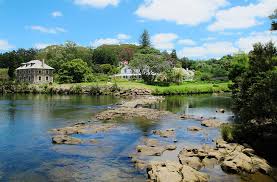
- Kerikeri Basin: Historic waterfront area with Stone Store and Kemp House - clearly marked on all maps as a major heritage site and tourist attraction
- Stone Store (1836): New Zealand's oldest stone building - iconic landmark visible on detailed maps, now a museum
- Rainbow Falls: Spectacular 27-meter waterfall just 3 km from town center on Rainbow Falls Road - popular walking track
- Kerikeri Airport (KKE): Bay of Islands Airport located 6 km south of town on Wiroa Road with daily flights to Auckland
- Kerikeri Road: Main thoroughfare through town with shops, restaurants, and all major services clearly marked
- State Highway 10: Primary route connecting Kerikeri to Paihia (20 min), Kaikohe (40 min), and wider Northland
When using GPS or digital maps, search for "Kerikeri, Northland, New Zealand" or enter the coordinates 35.2269° S, 173.9478° E for the town center. Most navigation systems will provide accurate directions to major attractions. Google Maps, Apple Maps, Waze, and other digital mapping services all clearly show Kerikeri's location and provide detailed street-level navigation with real-time traffic updates.
Kerikeri's position on the map makes it an ideal base for exploring the Bay of Islands region. The town's central location provides easy access to numerous beaches, islands, and attractions within a 30-minute drive. When planning your visit, use maps to identify nearby points of interest including Paihia (20 km, 20 minutes), Waitangi Treaty Grounds (15 km, 15 minutes), and Russell (25 km + ferry, 35 minutes total). Kerigold Chalets provides the perfect accommodation base for your Bay of Islands exploration.
Distance from Kerikeri to Key Bay of Islands Locations:
- Kerigold Chalets: 2 mins walk to the heart of Kerikeri
- Paihia: 20 km (20 minutes) - Bay of Islands tourist hub with ferry services to islands and dolphin cruises
- Waitangi: 15 km (15 minutes) - Treaty Grounds where New Zealand's founding document was signed in 1840
- Russell: 25 km + ferry (35 minutes total) - Historic waterfront town with colonial architecture and restaurants
- Matauri Bay: 30 km (35 minutes) - Stunning white sand beach with Rainbow Warrior memorial
- Kerikeri Airport: 6 km (5-minute drive to the airport) - Regular flights to/from Auckland
- Cape Reinga: 210 km (2.5 hours) - Northernmost accessible point where Tasman Sea meets Pacific Ocean
- Ninety Mile Beach: 180 km (2 hours) - Famous long sandy beach on west coast
Distances from Kerikeri to Major NZ Cities (as shown on maps):
- Auckland: 240 km south (3 hours drive or 45 min flight) - New Zealand's largest city, population 1.7 million
- Whangarei: 80 km south (1 hour drive) - Northland's regional capital and largest city, population 55,000
- Hamilton: 370 km south (4.5 hours drive) - Waikato region's main city
- Tauranga: 430 km south (5 hours drive) - Bay of Plenty coastal city
- Rotorua: 450 km south (5.5 hours drive) - Geothermal attractions and Maori culture
- Wellington: 730 km south (9 hours drive or 1.5 hours flight via Auckland) - New Zealand's capital city
- Christchurch: 1,200 km south (2 hours flight via Auckland) - South Island's largest city
- Queenstown: 1,600 km south (2.5 hours flight via Auckland) - Adventure capital of New Zealand
Map References and Administrative Details:
- Region: Northland - New Zealand's northernmost region with warmest climate and 2,000+ sunshine hours annually
- District: Far North District - local government area for rates and services
- Area: Bay of Islands - tourist and geographic region with 144 islands for sailing and fishing
- Nearest Major City: Auckland (240 km south) - New Zealand's largest city with international airport
- Nearest Regional Center: Whangarei (80 km south) - Northland's largest city with full services
- Time Zone: NZST (UTC+12) / NZDT (UTC+13 during daylight saving October-April)
- Postal Code: 0230
Kerikeri's position on New Zealand maps reveals its strategic importance as a gateway to the Far North. The town sits at the intersection of State Highway 10 (which runs north-south through Northland) and local roads connecting to the Bay of Islands' coastal areas. This central position within the Bay of Islands region makes Kerikeri an ideal base for exploring both coastal and inland attractions throughout Northland.
Understanding Kerikeri's Map Position:
- Upper North Island: Located in New Zealand's northernmost region with subtropical climate - warmest area of NZ with minimal frost
- Bay of Islands: Positioned in this famous tourist region with 144 islands and pristine beaches for water sports and sailing
- Strategic Location: Central to Northland's attractions including Cape Reinga, Ninety Mile Beach, Kauri forests, and historic sites
- Easy to Find: Clearly marked on most New Zealand maps due to its historical significance (second oldest European settlement, 1819) and tourism importance
- Coastal Proximity: 16 km inland from Pacific Ocean, providing access to beaches while maintaining inland tranquility
- Highway Access: On State Highway 10 with clear signage from main State Highway 1 - well-maintained roads throughout
Most physical maps of New Zealand clearly show Kerikeri due to its historical significance and popularity as a tourist destination. Look for it in the upper North Island, in the area labeled "Bay of Islands" or "Northland." Tourist maps often highlight Kerikeri's historic sites, making it easy to identify. The town's position on State Highway 10 makes it a natural navigation reference point when exploring the region.
When planning your visit to Kerikeri, studying a map of New Zealand helps you understand the town's relationship to other destinations. Kerikeri's northern position means it's often the starting or ending point for Northland road trips. Many visitors fly into Kerikeri Airport or drive from Auckland, then use the town as a base to explore the wider region including Cape Reinga (northernmost point), the Kauri Coast (giant ancient trees), and the Bay of Islands (144 islands for sailing and fishing).
Modern digital maps provide detailed street-level views of Kerikeri, showing the town's layout, major roads, attractions, and amenities. Google Maps and Apple Maps both offer comprehensive coverage of Kerikeri, including real-time traffic information, business locations with reviews, and user-generated photos. These tools make navigating to and around Kerikeri straightforward for visitors, whether you're driving from Auckland or exploring once you arrive.